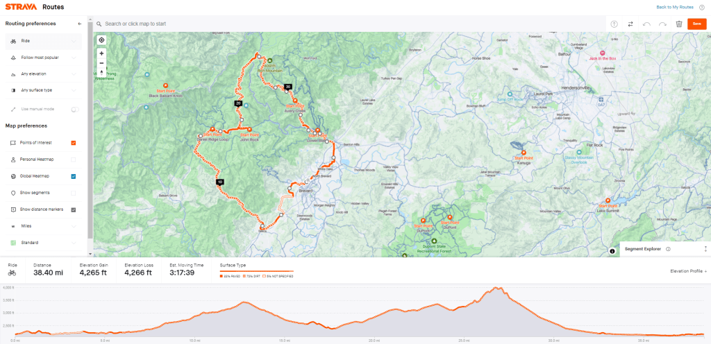
3-4 Hours – Featuring Cathey’s Creek Road, Davidson River Road/Trail, Headwaters Road, Avery Creek Road
38 Miles; 4,300′; ~70% Gravel
We all have favorite routes, this is mine. This route will take you on the best maintained gravel roads in this part of the forest and really bring out the strengths of your gravel bike. To start, you’ll ride south out of town towards Rosman. The strava route link below goes through Cashiers Valley, which is a great bike friendly road paralleling the highway. Unfortunately, we do have to hop on the highway for a half mile, but it is two lanes and a shoulder opens up halfway through. This is the only section where you’ll consistently interact with cars. After the highway we’ll hop on Selica Rd which will turn in to Cathey’s Creek Road. At the 6 mile mark, you’ll be done with pavement for a while. Cathey’s creek is one of the more underutilized roads in the forest, but still well maintained. If you’re feeling good this is a great climb to test the legs out. Will be around 30 minutes of moderate climbing with the KOM around 26 minutes. Just on the other side of the top of this climb is Glouchester Gap. Here you’ll have a big intersection with all sorts of add on options. We’ll go into those on different routes! Go right through a gate and start descending down towards the Davidson. This road has been closed since Hurricane Fred in 2021, so it hasn’t seen as much maintenance or traffic as you would like. Expect loose gravel and take your time. Some great sights along the way. Continue to descend down the Davidson until it turns to pavement. As soon as this happens, a single track trail – Davidson River Trail – will pop up on your right. Take that to get a little easy singletrack as you descend the river valley. Keep in mind, this trail sees heavy usage during busy times. If you’re seeing a lot of forest users, might make sense to just continue on the paved road down they will reconnect. At the end of the Davidson River trail, you’ll turn right back on to the road for a quarter mile before turning left on to 475B (aka headwaters). 475B is one of the more popular access roads in the forest. Expect some cars and lots of bikes. A few small waterfalls and viewpoints will present themselves as you climb. Viewpoints are best in the winter when the leaves are down, but you can sneak in some views through the foliage too! This rolling climb is another great one for some efforts to test the legs, or just enjoy the scenery. After the top, you’ll descend to the highway (276) and head up the highway for a half mile before turning right on to FR 477. Last gravel climb of the day, should take around 10-15 minutes so empty the tank! After the climb you’ll descend Avery Creek Road. You will see many peculiar looking bikes with very fat tires and springs on them climbing this road to access all of the world class mountain biking this road accesses. When this road ends, you’ll turn left onto 276 paved road and ride back in to town via the bike path. There is a cheeky short cut through the campground that I’ve included in the strava file. This really cuts down on the number of car interactions and makes for a nice cooldown back into town.
Strava Route:
https://www.strava.com/routes/2940001306548658984